Land Registration
Every individual, whether alone or in a group, has the right to own property. However, how can one ensure that their ownership is officially recognized and protected from infringement, allowing them to assert their rights against any violator? In order to obtain full ownership that is legally recognized and cannot be infringed upon, and that can be used to defend against any third party, one shall register the land with the Cadastral Administration Office, which operates under the Ministry of Land Management, Urban Planning, and Construction.
Type of Registration
There are two types of land registration such as initial land registration (i) and subsequent land registration (ii).
I.Initial Land Registration
Initial land registration refers to the process of registering land that has never been registered before or the land that does not yet have a certificate of ownership. The Initial Land Registration may carried out through two methods such as Systematic Land Registration (hereinafter referred to as “SLR”) (1), and Sporadic Land Registration (hereinafter referred to as “SPLR” (2).
1-Systematic Land Registration (SLR)
The procedure for systematic land registration is conducted publicly and requires the participation of local citizens. This participatory approach ensures transparency in the registration process, helps prevent future land disputes, and enables the government to manage land resources more effectively.
Under this initiative, land is registered comprehensively by area covering villages, communes, districts, municipalities, and provinces as designated by the state. Upon completion, rightful landowners will be issued a Certificate Acknowlegement of Immovable Property, commonly known as a (“Hard Title”) which confers full and permanent ownership rights.
The procedure for systematic land registration consists of the following five steps:
Step 1: Preparation
Following mutual agreement with the Ministry of Land Management, Urban Planning, and Construction, the Provincial or Capital Governor shall issue a public announcement defining the area and boundaries of the land to be adjudicated. This may be done through visual representation on a map, by descriptive method, or by using both methods.
Once the area for adjudication has been determined, the Provincial or Capital Governor must appoint an Administrative Commission, composed of the following members:
- A representative of the Provincial/Capital Governor, as Chairperson;
- The area adjudication manager, acting as Cadastral Officer, as a member;
- A responsible officer from the Provincial/Capital Department of Land Management, Urban Planning, Construction, and Cadastral Affairs, as a member;
- The District/Municipality Governor or their representative, as a member;
- The Commune Chief/Sangkat Chief or their representative, as a member;
- Two respected elders from the area under adjudication, as members.
The Provincial or Capital Governor must make a public announcement of the date and location of the public meeting to disseminate the declaration on the adjudication area. This notice must be posted at least 7 days prior to the meeting, in clearly visible places within the village or directly within the adjudication area.
Step 2: Technical Operations
This step consists of two main components such as fieldwork and office work.
A. Fieldwork
Once the adjudication area has been designated, the General Department of Cadastre and Geography must appoint the following officials to carry out duties within the designated area as below:
- Area Adjudication Manager
- Boundary Demarcation Officer
- Surveying Officer
- Adjudication Officer
The Area Adjudication Manager is authorized to lead and issue necessary instructions to the appointed technical officers.
Boundary Demarcation Officers and Surveying Officers are authorized to enter any immovable property within the adjudication area to determine boundaries and conduct measurements. They may also summon relevant parties to provide oral statements, documents, or other evidence concerning the boundaries of specific land parcels.
Adjudication Officers have the authority to request any necessary information to carry out adjudication duties. They may summon relevant individuals to provide oral testimony, documents, or other forms of evidence related to the adjudication process.
In cases where disputes arise concerning land boundaries or ownership rights over a particular land parcel, the Adjudication Officer must record the matter in the land data collection form, indicating that the land parcel is subject to dispute.
B. Office Work
Data collected from the fieldwork must be entered into a computer system in order to generate the cadastral maps, landowner name lists, and the master land register book.
Step 3: Public Display of Adjudication Documents
The public display of adjudication documents, which includes cadastral maps and the list of landowners, must be conducted for a period of 30 days in a location that is easily visible for public inspection within the adjudication area.
The provincial or municipal authorities are responsible for disseminating a public notice regarding the display of adjudication documents, based on the proposal of the Administrative Commission.
During the public display period, any individual listed in the documents or any person having an interest in a particular land parcel who believes that the adjudication documents are inaccurate or incomplete, may file an objection with the Administrative Commission.
Upon receiving the objection, the Commission must notify all concerned parties and, after conducting consultations with the disputing parties, attempt to resolve the issue amicably.
If any objection or dispute cannot be resolved at the local level, the matter must be referred to the National Cadastral Commission, in accordance with the procedures stipulated by Sub-Decree No. 47 ANK/BK dated May 31, 2002, on the Organization and Functioning of the Cadastral Commissions, and Declaration No. 112 DNS/PRK dated August 21, 2002, issued by the Ministry of Land Management, Urban Planning, and Construction, concerning the Principles and Procedures of the Cadastral Commissions.
In cases where no objection or dispute is raised during the public display period, the information recorded in the publicized documents shall be deemed official and legally valid, except in cases where the owner of the land or immovable property provides clear supporting documents and valid reasoning for not having filed an objection during the display period. In such instances, the concerned individual may submit a petition to the Cadastral Commission for resolution in accordance with the prescribed legal procedures.
Step 4: Finalization of Adjudication Documents
After the conclusion of the public display period of adjudication documents:
The Adjudication Area Manager must sign the cadastral maps and the list of landowners.
The Chairperson of the Administrative Commission must sign the cadastral maps, the list of landowners, and the report on the results of the adjudication.
The Director of the Provincial/Municipal Department of Land Management, Urban Planning, Construction, and Cadastral Affairs must countersign the cadastral maps, the list of landowners, and the adjudication report, specifically in the section reserved for the signature of the Provincial or Municipal Governor.
The Provincial or Municipal Governor must sign the cadastral maps, the list of landowners, and the adjudication report. In case of any disagreement, the reasons must be clearly stated.
The Minister of Land Management, Urban Planning, and Construction shall provide the final official approval by signing the cadastral maps, the list of landowners, and the adjudication report.
Once the adjudication documents are fully finalized, all adjudication documents, along with any other documentation obtained during the adjudication process, must be submitted to the Cadastral Administration for registration.
Step 5: Title Issuance
After the land parcels included in the adjudication documents have been officially registered, the Ministry of Land Management, Urban Planning and Construction (or the Provincial/Municipal Department that received delegation from the Ministry) must issue the Certificate Acknowledgement of Ownership over the Immovable Property Ownership for all land parcels within the adjudicated area.
II. Sporadic Land Registration (Individual Land Registration)
Because systematic land registration is a time consuming process despite being low cost, sporadic land registration was created to allow landowners who do not wish to wait for systematic registration to proceed with registering their land individually and receive the ownership title sooner. However, sporadic registration is typically more expensive.
1. Application for Land Registration
The land possessor must file a land registration application to the District/Khan/Municipal Cadastral Office via the Commune Chief/Sangkat Chief.
This step is very important because delegating this responsibility to the Commune or Sangkat Chief means they are responsible for verifying the actual situation of the land parcel, its occupation, and any related facts. Therefore, they are primarily accountable.
The District/Khan/Municipal Cadastral Office shall review the application:
If sufficient and appropriate: accept the application, record it in the application logbook, and set a date for boundary demarcation, measurement, and adjudication.
If inappropriate: make a note of the reason on the application and return it.
If incomplete: request additional documents.
If related to state land: coordinate in accordance with the Sub-Decree on the Cadastral Commission.
The District/Khan Governor must notify the applicant at least 14 days in advance of the scheduled date for boundary demarcation, measurement, and adjudication.
Public Notice of the adjudication must be posted at the District/Khan/Municipal Hall, Commune/Sangkat Office, and other public places such as pagodas, schools, or any easily visible locations.
2. Boundary Demarcation, Measurement, and Adjudication
Officials in charge must carry out the boundary demarcation and measurement on the date specified in the notification. Key principles include:
If the owner and adjoining landowners are present and agree, the boundary shall be demarcated accordingly.
If one party is absent or disagrees, the boundary shall be demarcated based on available documents, physical evidence, written or oral statements regarding the boundaries.
If the land parcel borders public land, the same approach applies.
If there is a boundary dispute that cannot be resolved immediately, it must be referred to the District/Khan Cadastral Commission for mediation and resolution according to the Sub-Decree.
Measurement of the land parcel is done after boundaries are set.
3. Public Display of Adjudication Documents
The adjudication documents include:
- A map of the land parcel,
- A sketch showing its location,
- A list of landowners,
- A data collection form (including parcel identity, owner identity, and adjudication date).
These must be displayed for 30 days in a visible public location within the adjudication area.
During this public display period, persons listed in the documents and any interested parties who disagree with the adjudication may file objections. Objections shall be mediated by the District/Khan Cadastral Commission. If unresolved, the case shall be referred to the Provincial/National Cadastral Commission.
4. Registration and Issuance of Title
After the adjudication documents have been finalized (signed by the Department of Land Management, the Provincial Governor, and the Minister of Land Management), the Cadastral Administration (General Department of Cadastre and Geography or the delegated Provincial Department) shall proceed to register and issue titles for land parcels with no disputes or objections.
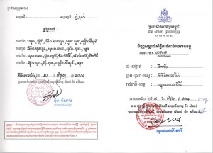
Remarkable for Title to Be Issuance.
Before 2019
There are two difference types of certificates that shall be issued for a Systematic Land Registration and a Sporadic Land Registration as the follwoing:
- Certificate of Acknowledgement of Ownership over the Immovable Property.
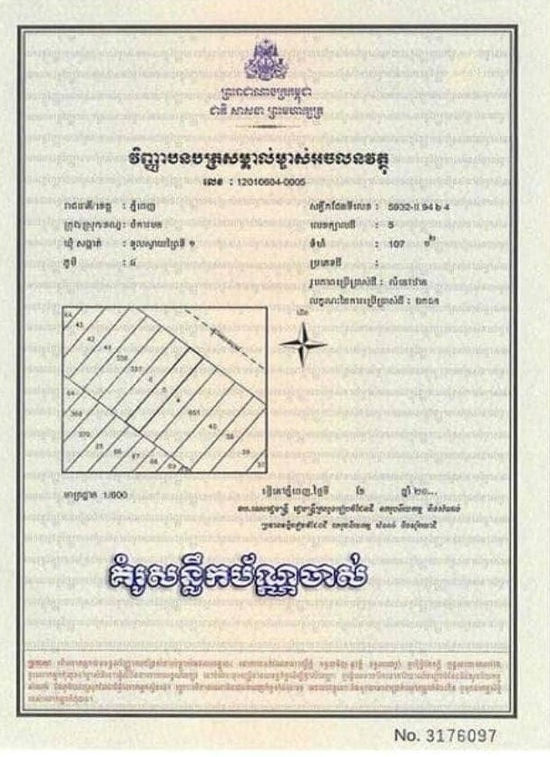
For Systematic Land Registration
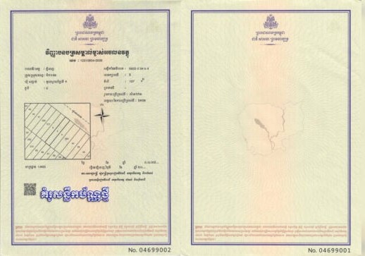
In 2019, New Plamplate of Certificate of Acknowledgement of Ownership over the Immovable Property.
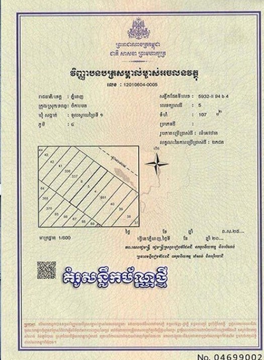
The Latest version of ertificate of Acknowledgement of Ownership over the Immovable Property
2. Certificate of Possessory Rights over the Immovable Property.
For Sporadic Land Registration
From 2019 onward
Both Systematice Land Registration and Sporadic Land Registration shall be issued the sample ertificate of Acknowledgement of Ownership over the Immovable Property.
Land Registration Fees
Fees for both systematic and sporadic land registration are set by Join Prakas No. 356 SorHorVor.BrorKor on Public Service of Ministry of Land Management Urban Planing and Construction dated April 26, 2019, issued by the Ministry of Economy and Finace and the Ministry of Land Management Urban Planning and Construction.
Summary by
This summary is for informational purposes only and does not constitute legal advice. It is not comprehensive, and readers should seek professional legal consultation for their specific circumstances. SOPHEAPCAMBOLAW retains full ownership of this content. Unauthorized reproduction, distribution, or use of any part of this article without prior written approval is strictly prohibited.
-ព្រះពុទ្ធ-
សព្វទានំ ធម្មទានំ ជិនាតិ
Sharing knowledge is the most worthwhile endeavor of all.

Leave a comment